Description
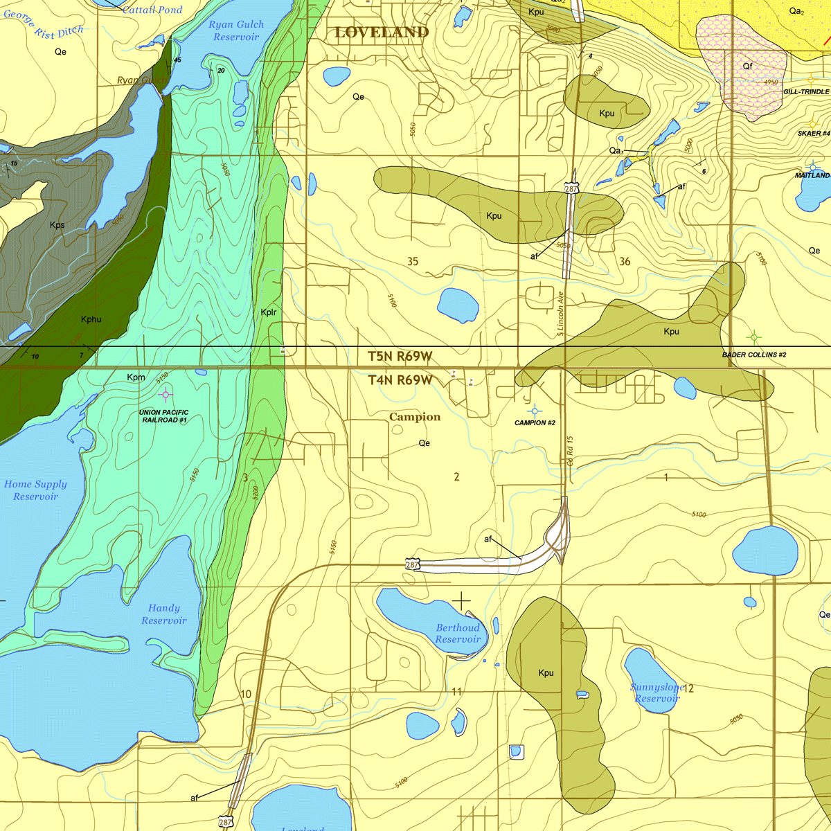
The purpose of this map is to describe the geology, mineral and ground-water resource potential, and geologic hazards of this 7.5-minute quadrangle located immediately east of the Front Range uplift of Colorado. The geologic map plates were created using field maps, structural measurements, photographs, and field notes generated by the investigators. The GIS data included in this package was brought into GeMS Level 3 compliance as of November 2022. Includes 2 plates and GIS data in a single zip file. Digital ZIP download. OF-17-03D
This mapping project was funded jointly by the U.S. Geological Survey through the STATEMAP component of the National Cooperative Geologic Mapping Program, which is authorized by the National Geologic Mapping Act of 1997, and also by the CGS using the Colorado Department of Natural Resources Severance Tax Operational Funds. The CGS matching funds come from the severance paid on the production of natural gas, oil, coal, and metals. Geologic maps produced through the STATEMAP program are intended as multi-purpose maps useful for land-use planning, geotechnical engineering, geologic-hazard assessment, mineral-resource development, and ground-water exploration.
From Plate 2:
The Berthoud quadrangle lies in the northern part of the Colorado Piedmont, near the western margin of the Denver Basin and approximately midway along its length. Like much of the piedmont the quadrangle has low relief (365 ft, 111 m). The uppermost and youngest bedrock, underlying all of the quadrangle, is the Pierre Shale (Kp), a marine formation deposited in the Cretaceous Interior Seaway during the Late Cretaceous (100-66 Mya). Oil and gas wells in the Berthoud quadrangle have penetrated Cretaceous through Permian formations below the Kp, but none of these formations are exposed in the quadrangle. The Kp strata dip gently east to southeast and older Kp members are exposed in the northwestern part of the quadrangle. Structural up-warping along the present-day Front Range occurred during the Laramide orogeny, which began 70 Mya.
The present-day topography results from evolution of the South Platte River and Arkansas River drainage basins during Quaternary time, beginning with removal of Miocene and older Tertiary rocks that once covered the Upper Cretaceous strata. The dominant Quaternary deposits of the Colorado Piedmont (including the Berthoud quadrangle) are fluvial sediments of the South Platte and Arkansas Rivers and their tributaries, and also eolian sediments derived both from these stream valleys and from bedrock exposures. The Little Thompson River in the Berthoud quadrangle lies within the South Platte drainage basin. The Quaternary history of the Berthoud quadrangle began with erosion of the Neogene landscape, likely during Gelasian and Calabrian time (2.58 to 0.781 Mya). This was followed by deposition of sand and gravel (Qg2) on valley floors during the middle and late Pleistocene. Subsequent erosion during late Pleistocene time topographically inverted these ancient valleys and left isolated remnants of Qg2 on some uplands. The Qg2 exposure at Twin Mounds possibly is a deposit of an ancestral Big Thompson River. This exposure aligns geographically with and likely correlates with Qg2 bodies in the Johnstown quadrangle (adjacent to the east) that are mapped in a swath southwest of and parallel to the present-day river. The other two Qg2 bodies in the Berthoud quadrangle may represent different ancient drainages. Erosion carved the Little Thompson River valley during the late Pleistocene, and deposited sand and gravel of the Holocene alluvium three (Qa3). Subsequent erosion and stream incision during Quaternary time left behind a few Qa3 deposits at elevations above the present valley floor. Beginning during the recession of the last glaciation in the late Pleistocene, and continuing into the Holocene, eolian deposits (Qe – loess) were deposited and later reworked or removed in places. Aggradation in the Little Thompson River flood plain occurred during the late Holocene, depositing Quaternary alluvium two (Qa2) in wide valley floors. Incision and some aggradation followed during the late Holocene, cutting into the Qa2 valley floors and depositing alluvium one (Qa1) in lower and narrower stream courses.
