Description
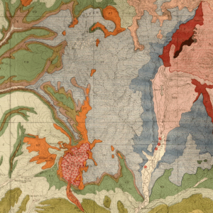
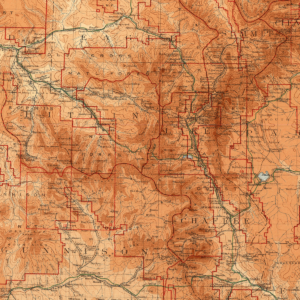
The purpose of this map is to describe the geology, mineral and ground-water resource potential, and geologic hazards of this 7.5-minute quadrangle located to the east-southeast of Denver, Colorado. The geologic map plates were created using field maps, structural measurements, photographs, and field notes generated by the investigators. Includes 2 plates and GIS data in a single zip file. Digital ZIP download. OF-16-02D
Matt Morgan, Senior Research Geologist and CGS Deputy Director, along with Senior Engineering Geologist (Emeritus) Jon White generated this map with special input from Richard Madole (surficial geology) and Shannon Mahan (OSL analysis), both of the USGS. This free release from the CGS includes two plates (with a geologic map, cross-section with correlation, oblique 3D view, and legend) along with the corresponding GIS data package that allows for digital viewing, all in a single zip file.
This mapping project was funded jointly by the U.S. Geological Survey through the STATEMAP component of the National Cooperative Geologic Mapping Program, which is authorized by the National Geologic Mapping Act of 1997, and also by the CGS using the Colorado Department of Natural Resources Severance Tax Operational (STAX) Funds. The CGS matching funds come from the severance paid on the production of natural gas, oil, coal, and metals. Geologic maps produced through the STATEMAP program are multi-purpose information sources useful for land-use planning, geotechnical engineering, geologic-hazard assessment, mineral-resource development, and ground-water exploration.
This particular 7.5-minute, 1:24,000 quadrangle is situated within the Denver Basin, a Laramide-age structural basin that is an important resource for water along with oil & gas. Growth of the Denver metro area is occurring in the northern half of the quadrangle which is crossed by Interstate 70 and is minutes from Denver International Airport. Dips within the quadrangle typically range from 3° to 7° to the N-NE which reflects the regional structural dip of the basin. Bedrock units consist of the lower part of the Dawson Arkose and the Denver Formation. The widespread Dawson Arkose is white to tan in color and composed of cross-bedded arkoses, pebbly arkoses and arkosic pebble conglomerates with sparse claystone and siltstone beds. The arkoses were shed off the uplifting Front Range into the subsiding Denver Basin during the latter phases of the Laramide Orogeny. Cobble-rich conglomeratic lenses were recognized in the lower part of the Dawson Arkose and represent localized flooding events in a typically quiet fluvial environment. The Denver Formation is finer grained, more clay rich, and yellower in color than the overlying Dawson Arkose and is part of a low-energy alluvial plain environment also related to the Laramide. The units are separated by a basin-wide, yet occasionally discontinuous variegated paleosol that is a regional unconformity and an important time-stratigraphic marker at the Paleocene-Eocene boundary.
Surficial deposits consist of middle Pleistocene to Holocene flood-plain and terrace-forming alluviums and Holocene sand deposits of predominantly eolian origin. The sand deposits are composed of disaggregated sediments derived from the weathering and subsequent mobilization of the underlying Dawson Arkose. New Optically Stimulated Luminescence (OSL) ages, collected during this project, indicate that these eolian deposits were first active during the lowermost Holocene. High-level gravel deposits of Neogene-early Quaternary age cap isolated buttes in the southern half of the quadrangle. These gravels consist of cobbles and boulders of granite, quartzite, sandstone and tuffaceous igneous rocks and were likely derived from the erosion of the late Eocene Castle Rock Conglomerate.