Description
Describes the geologic setting and mineral resource potential of this 7.5- minute quadrangle in the southern Mosquito Range of central Colorado. Includes cross-section, correlation of map units, map symbols, booklet of extended descriptions of map units, structural geology, economic geology and selected references. 27 pages. 1 color plate (1:24,000). Digital PDF download. OF-00-01D
from the Introduction:
The Jack Hall Mountain quadrangle is located in western Fremont County in the southern part of the Mosquito Range. This quadrangle includes a deeply dissected terrane that is transitional from the high plains upland located north of this map area to the deeply incised canyon of the Arkansas River that is located south of this quadrangle.
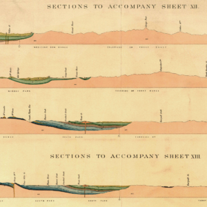
The oldest rocks exposed in the quadrangle are Early Proterozoic metamorphic and igneous rocks, which are overlain unconformably by Paleozoic sedimentary rocks, Tertiary volcanic and sedimentary rocks, and Quaternary alluvial, terrace, and colluvial deposits. The Late Cretaceous Whitehorn Granodiorite intruded Paleozoic sedimentary rocks. Steep faults offset Proterozoic and Paleozoic rocks. Lower Paleozoic rocks occur as isolated exposures in the northern and central parts of the map area, and a folded sequence of upper Paleozoic rocks occurs in the southwestern part of the map area. Late Cretaceous plutonic rocks and Tertiary volcanic and sedimentary rocks are not cut by faults. Tertiary volcanic rocks and volcanogenic sedimentary rocks cover Proterozoic and Paleozoic rocks over much of the quadrangle. Volcanic rocks are composed mainly of silicic welded tuff and air-fall tuff, but in the eastern part of the map area flow rocks of intermediate composition overlie silicic tuffs. Remnants of Quaternary pediments occur in the southwestern part of the map area and terraces occur along prominent drainages. Loess occurs as isolated deposits in some drainages and alluvial and colluvial deposits occur in modern streams.
Structures in the Jack Hall Mountain quadrangle are dominated by the north-trending Weston-Pleasant Valley fault in the central part of the map area. The Weston-Pleasant Valley fault was active during deposition of late Paleozoic strata, and slip on that fault ceased before intrusion of the Late Cretaceous Whitehorn Granodiorite. Some slip on the Weston-Pleasant Valley fault was probably strike-slip motion because a negative flower structure occurs along the fault. In the southwestern part of the map area the Badger Creek fault also was active during late Paleozoic time, and slip on this fault may have controlled thicknesses of late Paleozoic rock units. Slip on the Badger Creek fault may be related to slip on the Weston-Pleasant Valley fault. Medium-scale folds and faults of small separation occur scattered through lower and upper Paleozoic rocks.
Mineral deposits in the Jack Hall Mountain quadrangle consist primarily of precious- and base-metal vein deposits in Late Proterozoic rocks and stratabound copper and silver deposits that occur at the angular unconformity at the base of member four of the Pennsylvanian and Permian Sangre de Cristo Formation. Surface exposures of these copper and silver deposits are of local extent, and an adit was excavated into one of these stratabound occurrences. Davis and Streufert (1990) and Vanderwilt (1947) mention the presence of small gold vein and placer occurrences in Whitehorn Granodiorite near the abandoned settlement of Whitehorn in the Cameron Mountain quadrangle. There are no readily available detailed descriptions of these occurrences.