Description
Engineering geology report for planning Districts 7 and 13, State of Colorado. 25 pages. 2 plates (1:250,000). 10 figures. Digital PDF download. EG-03D
Excerpt from the report:
This report was originally prepared for Planning District 7 which has since been divided into two planning districts, 7 and 13. The purpose of this report is to present the results of a comprehensive investigation of the geology and engineering geology of Planning Districts 7 and 13. Planning Districts 7 & 13 include the counties of Lake, Chaffee, Fremont, Custer, Pueblo, Huerfano and Las Animas.
Within the Planning Districts, specific geologic factors which should be considered to insure safe, efficient and environmentally sound land use decisions. This investigation was done on a reconnaissance basis and the factors include, but are not limited to, the following:
a. Mineral resources which affect land use decisions
b. Massive land movements or other unstable surface conditions
c. Areas of swelling soils, settling soils or other soil factors that will affect foundation construction
d. General areas of flood danger and/or erosional hazards
e. Areas of high water table, both permanent and seasonal
f. General geologic constraints that will affect selection and operation of solid waste disposal sites
g. Pollution potential and other possible hazards associated with old mine tailing dumps.
h. Other critical factors which may become evident during the course of the study.
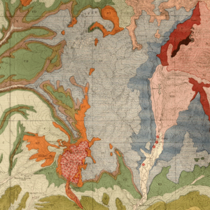
The report identified six problem areas in Planning District 7. Problem area I is the Leadville mining district in northeastern Lake County. Problem area II is the Spanish Peaks region with the associated radial dike swarms. Problem area III covers disseminated areas of potential avalanches. Such areas are common in alpine regions, which includes the Sangre de Cristo Range, the Wet Mountains, the Mosquito Range and the Sawatch Range. Problem area IV encompasses areas that were covered by glaciers in the past. Glaciers have covered most of the high mountain ranges, including the Sangre de Cristo Range, the Mosquito Range, and the Sawatch Range. Problem area V includes areas of extremely complex geology. There are several located in the major mountain ranges, including the Mosquito, Sangre de Cristo, Sawatch, and Wet Mountain Ranges. Problem Area VI includes groundwater in Pueblo County, areas of which may be contaminated significantly by radioactive material. Specifics of these problem areas are provided in the report.