Description
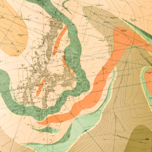
Text discusses rapid erosion, mud flows, landslides, and flooding which present extreme problems in the Marble area. Includes three plates: 1) Engineering geologic map, 2) Part of USGS geologic map of Marble Quadrangle, and 3) Detailed topography of major mud flow fan area. 44 pages. 19 figures. 3 plates (various scales). Digital PDF download. MI-08D
From the Introduction:
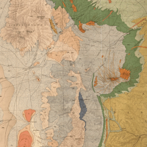
During the field season of 1999, Colorado Geological Survey (CGS) personnel conducted a reconnaissance-level investigation of naturally degraded surface waters associated with hydrothermal alteration in Colorado (Figure 1). Data from this study may be useful when regulatory agencies set stream standards. This information could also be useful for determining remediation goals for past and/or future mining operations.
Many of these sites were initially identified by water testing done in conjunction with an abandoned mine inventory conducted by the CGS for the USFS from 1991 through 1998. Personnel from the U.S. Geological Survey, the Colorado Division of Minerals and Geology, and Colorado State University were also important sources of preliminary information. A publication on iron occurrences in Colorado (Harrer and Tesch, 1959) describes numerous bogiron deposits, many which are associated with naturally degraded water.
A study of this scope cannot catalog and characterize every naturally degraded, metal-rich stream in Colorado. It may serve as a guide to identify areas of Colorado that are susceptible to these phenomena and provide general information regarding water chemistry at these occurrences. Many of the areas described in this report should be the foci of detailed watershed characterization studies to better understand the natural and anthropogenic processes involved in the surface-water chemistry.