Description
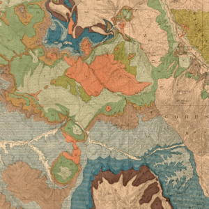
A collaboration between the CGS and the Denver Museum of Nature & Science (DMNS) generated a new stratigraphic chart for the state of Colorado. This color chart was designed from the ground up to illustrate the Proterozoic to Holocene stratigraphy that spans the state’s many sedimentary basins. A collaborative effort led by Robert Raynolds and James Hagadorn, the chart builds upon the work of dozens of colleagues and updates Richard Pearl’s seminal 1974 stratigraphy chart. The chart leverages the community’s stratigraphic work in both the subsurface and outcrop, and depicts new geochronologic constraints for many units. To facilitate comparison of strata to external forcing factors, the chart employs a linear timescale. Each unit’s dominant depositional environment is depicted as are major mountain building events, erosional events, and regional unconformities. The PDF file may easily be printed up to its original size ~42×39-inches. Digital PDF download. MS-53D
From the chart:
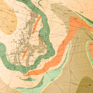
Colorado’s stratigraphy is dominated by gaps. The distribution of strata reflects the tectonic and climatic evolution of each of the region’s eleven basin areas, depicted in the map below. To foster comparison of these patterns, we have organized the stratigraphy using a linear timescale and illustrated where orogenic uplift has led to removal of strata or nondeposition. Not all orogenic features are illustrated on the chart. For example, some orogenies caused sediment ponding and accumulation in intermontane basins, such as during the Laramide in northwestern Colorado. In the past ~10 Ma, regional uplift has raised Colorado and has allowed the modern landscapes to be created due to erosion. The chart’s color scheme for stratigraphic units gives a sense of dominant lithologies and depositional environments across basins. Updates to this chart, as well as additional stratigraphic resources, such as stratigraphic and structural cross-sections, may be found at http://coloradostratigraphy.org. To learn more about the unit names on this chart, resources are available at the U.S. Geological Survey’s Geolex site. This chart scaffolds on the work of Richard H. Pearl’s 1977 compilation (Rocky Mountain Association of Geologists, Special Publication 2). With the exception of the Carboniferous and Permian periods, this data has been re-cast against the International Commission on Stratigraphy’s chronostratigraphic chart v. 2015/01, updated at http://stratigraphy.org.