Case Study: The Trinidad, Colorado Earthquakes
2011-08-22 | CGS Admin
[ED: Originally published in 2011 by Vincent Matthews, former State Geologist at the CGS.]
Around midnight on August 22, 2011, Colorado experienced its largest earthquake in half a century. The earthquake was quickly relegated to obscurity by the 5.8 earthquake that occurred about 12 hours later in Virginia. Colorado’s 5.3 magnitude earthquake occurred in a sparsely populated area, whereas Virginia’s earthquake affected many people. Before the Colorado earthquake could even hit the evening news, it was overshadowed by the earthquake “back East.”
The Director of the National Earthquake Information Center (NEIC) and the Director of the CGS conferred early in the morning before the Virginia quake and agreed that it would be advisable to deploy a portable seismic network to better understand what was going on in the Trinidad area. That morning, the NEIC sent their team to deploy the network and the CGS put a team on the ground to make a preliminary damage assessment (Morgan and Morgan, 2011). Fortunately, the Virginia quake held off just long enough for the NEIC crew to install the instruments in Colorado before being sent off to the east coast.
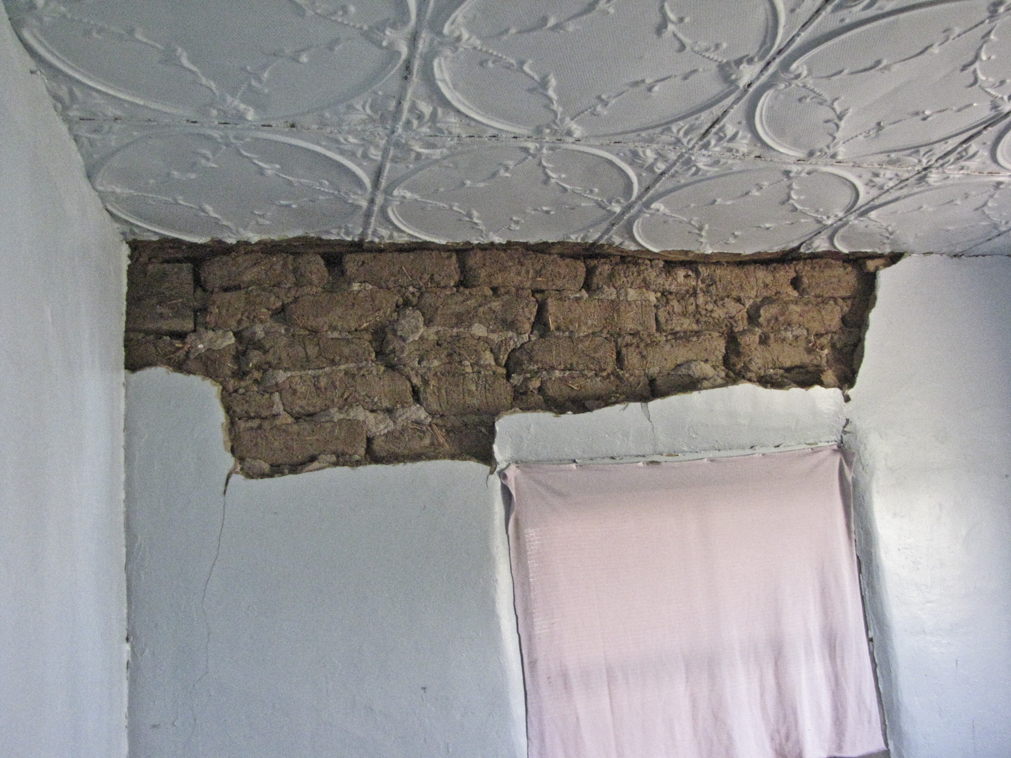
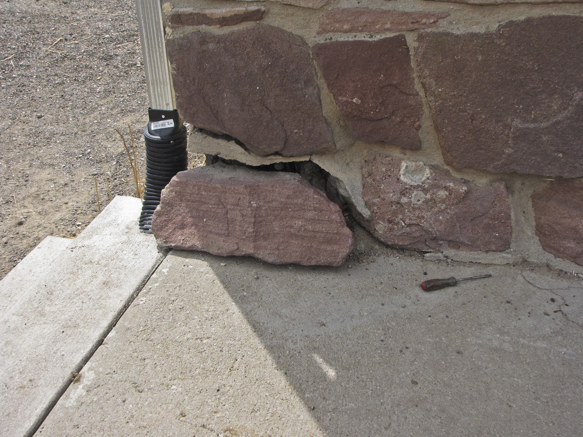
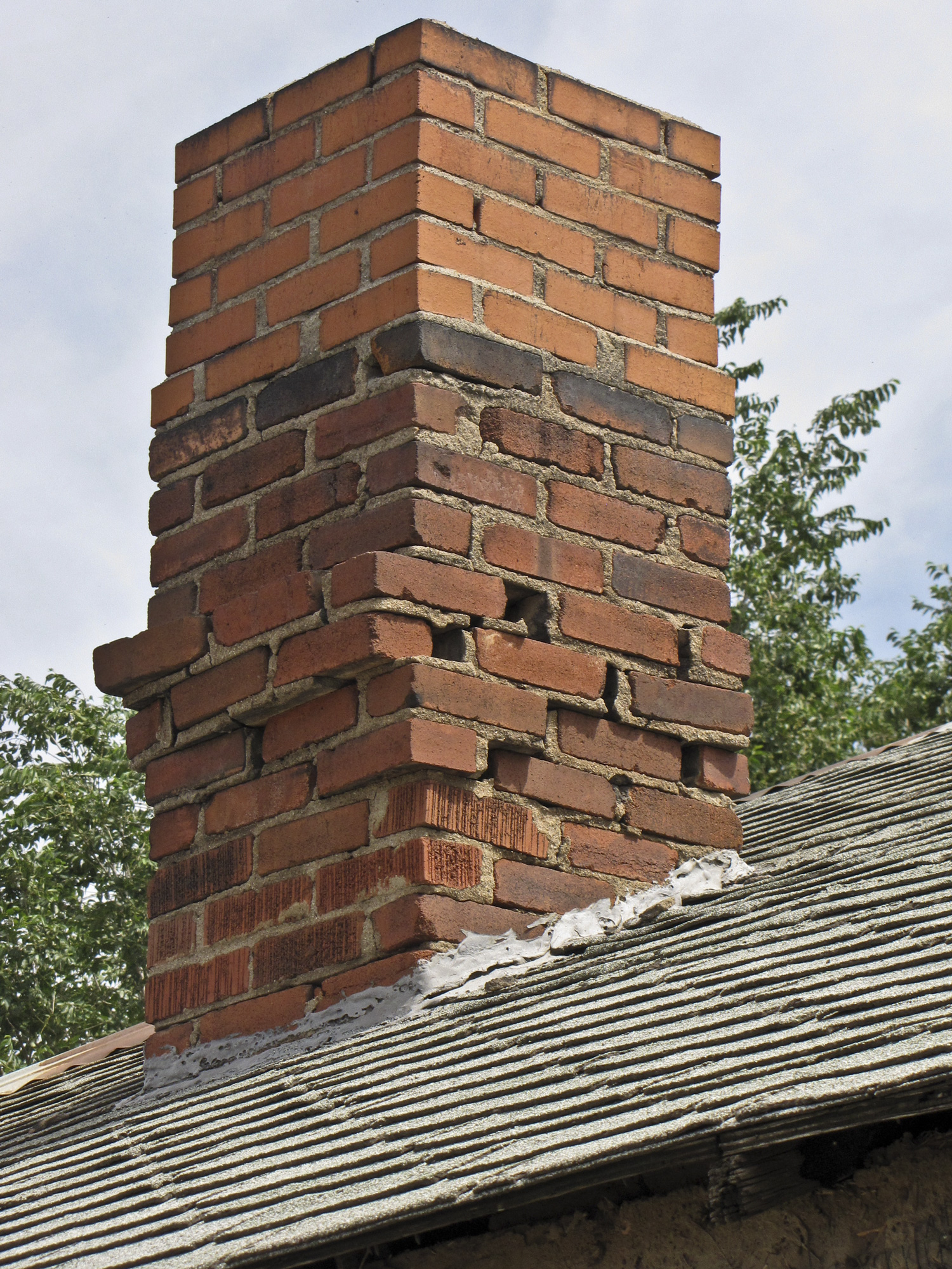
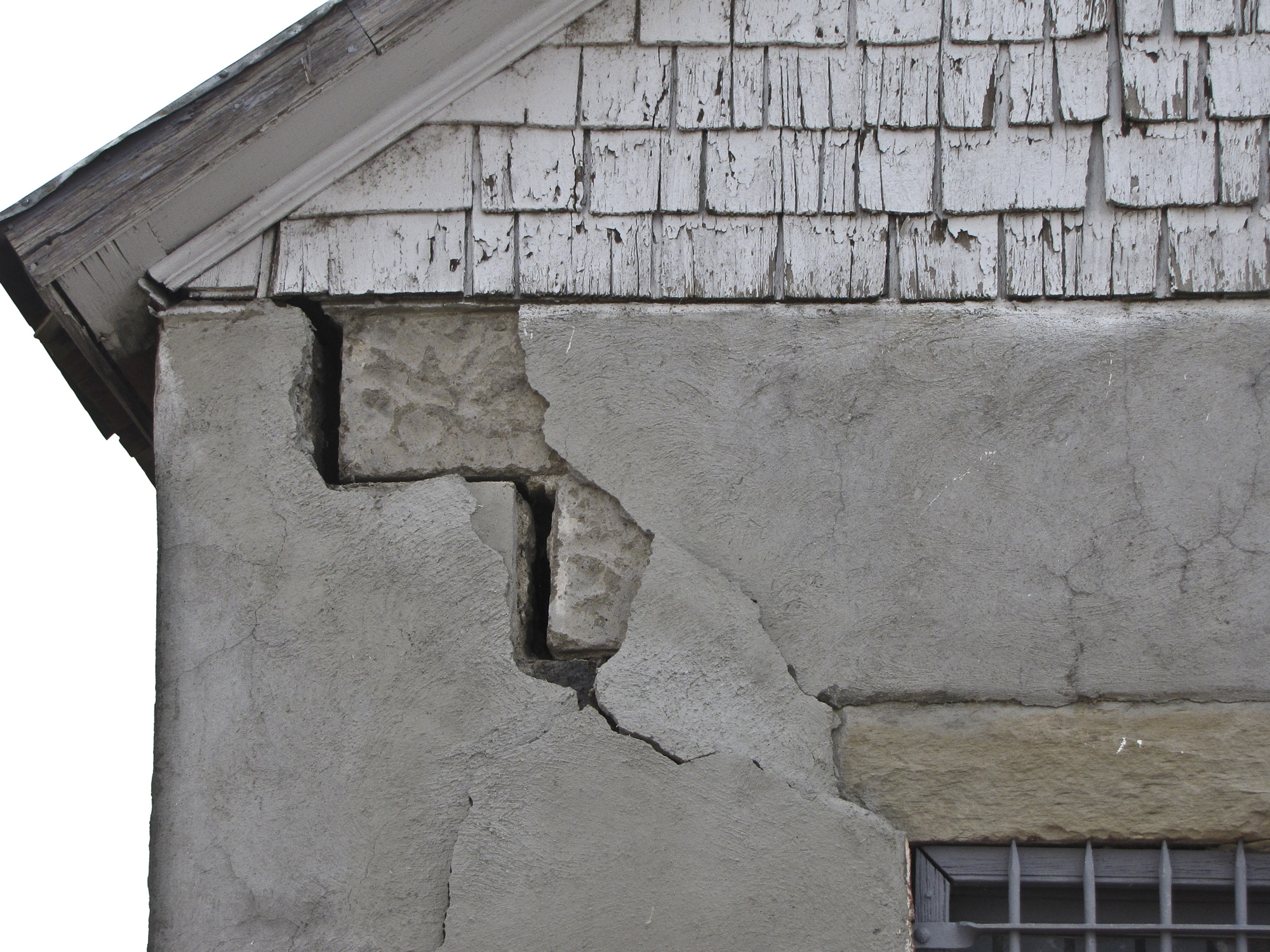
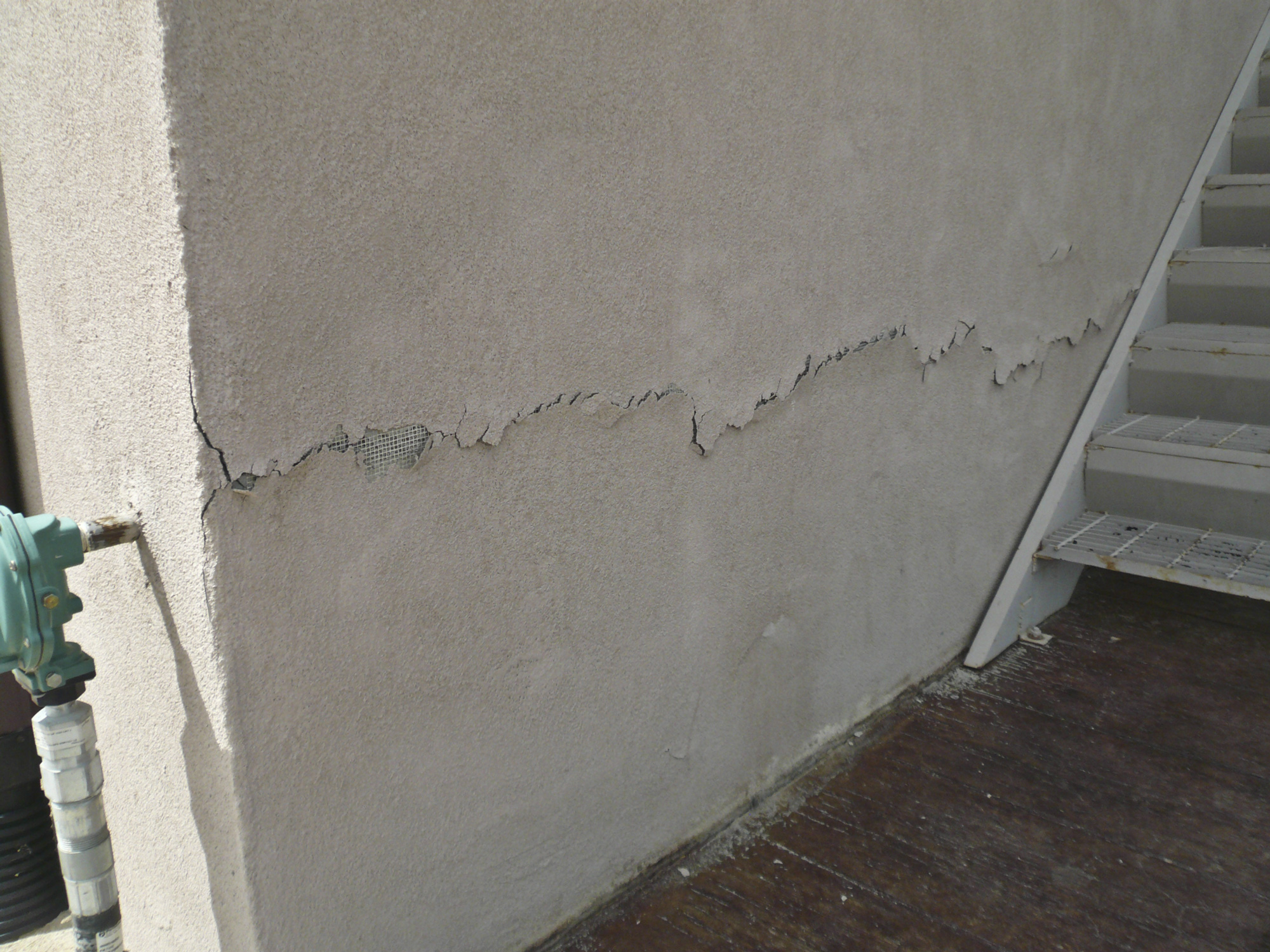
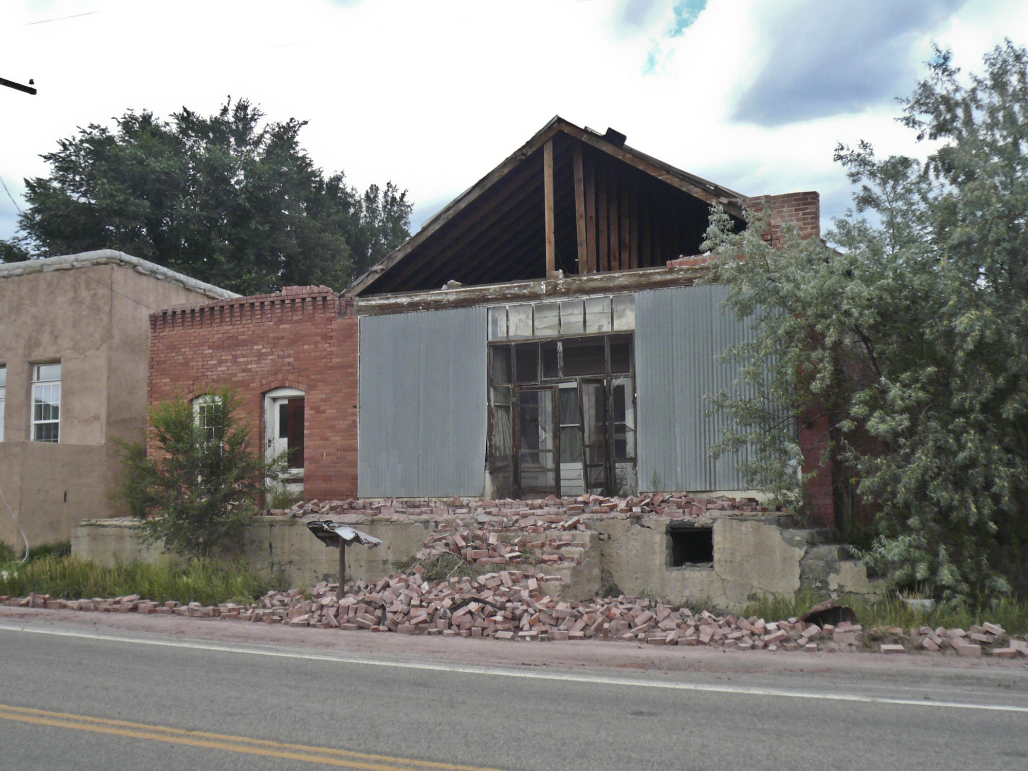
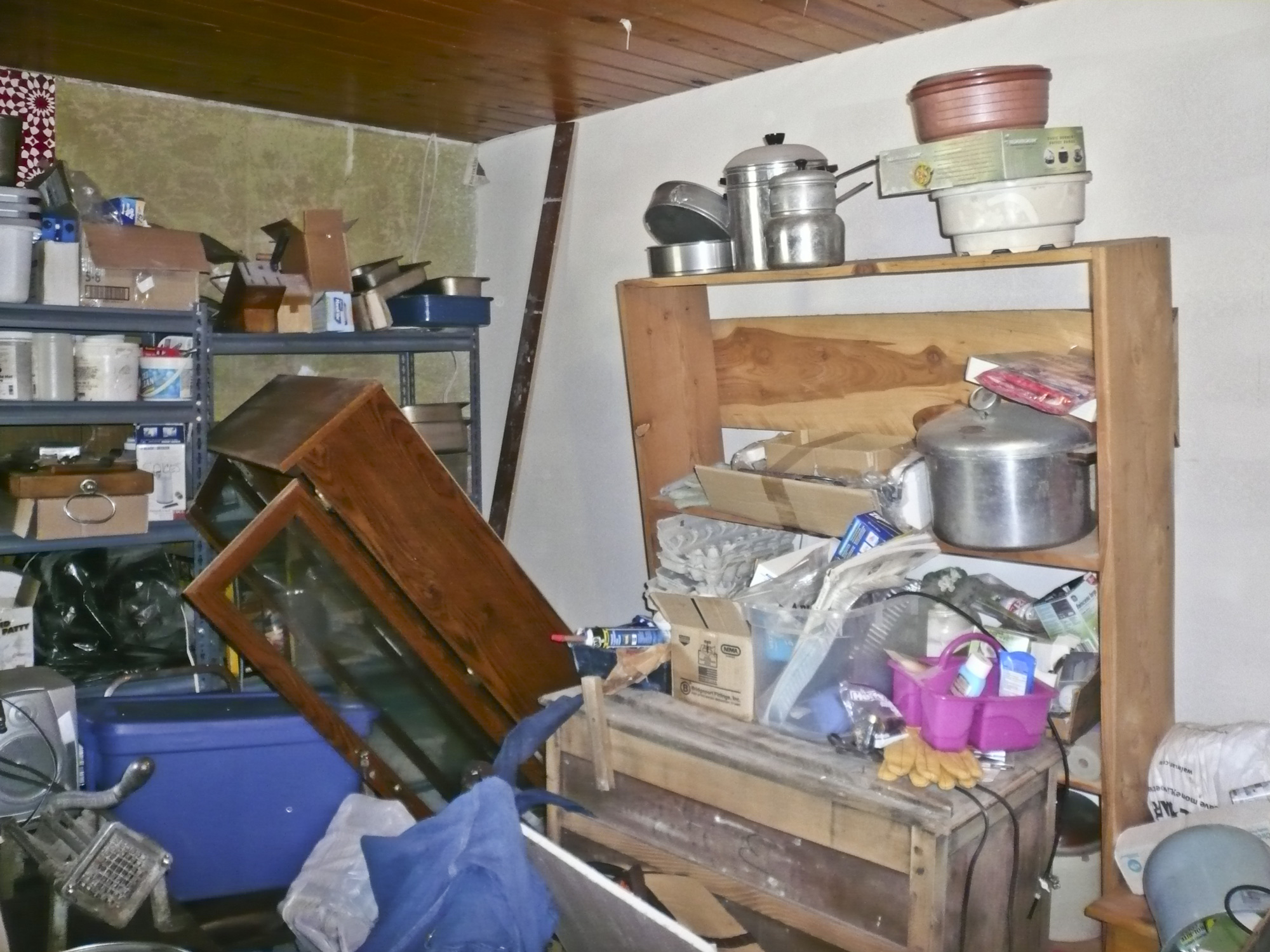
Although occurring in a sparsely populated area about 15 miles southwest of Trinidad, Colorado this earthquake caused significant damage to many of the buildings in the area. Forty six structures were damaged, and two residences were condemned.
History, Geologic Setting, Oil & Gas Activities
This 2011 earthquake was located near a damaging 4.6 magnitude earthquake that occurred in 2001. Long-term residents of the area reported that the intensity of the 2001 quake was similar to an even earlier earthquake in 1973. The 2001 swarm was also collaboratively investigated by the NEIC and CGS. The NEIC deployed instruments and analyzed the seismicity, and CGS investigated the geology (Meremonte and others, 2002; Matthews, 2002). The data were all consistent with the earthquake source being a previously unmapped, northeast-southwest-trending, normal fault dipping steeply to the southeast (Figure 1).
Colorado is essentially being pulled apart where the Rio Grande rift cuts north/south across the central part of the state. The high mountains in the state (58 named peaks greater than 14,000 feet above mean sea level) are a result of uplift on faults (with associated earthquakes) that are part of the Rio Grande rift system. The state has experienced numerous natural earthquakes, including a magnitude 6.6 earthquake (estimated) in 1882 (Kirkham and others, 2012). Hundreds of written reports relative to Colorado’s Neogene (23-2.58 Ma) fault and earthquake history can be found in the CGS “Earthquake Reference Collection”.
The nearest Holocene (<11,400 yrs. B.P.) fault is 35 miles to the west of the Trinidad swarms (Figure 1). The Northern Sangre de Cristo fault is the boundary between the Sangre de Cristo uplift and the San Luis Basin of the Rio Grande rift. Another fault (the Cheraw) that displaces Holocene deposits lies on the Great Plains about 80 miles to the northeast of the two swarms (Kirkham and others, 2012). Like the two swarms in the Trinidad area (Figure 1), the Cheraw fault also trends roughly northeast-southwest.
The Trinidad area has a history of natural earthquakes (Kirkham and others, 2012):
- In 1966, a 4.5 magnitude earthquake was reported northeast of Trinidad.
- In 1973, a swarm of four earthquakes ≤4.2 magnitude was reported west of Trinidad.
- In 1983, a magnitude 3.2 earthquake was reported northeast of Trinidad.
- In 1996, a series of three earthquakes ≥3.2 magnitude hit northeast of Trinidad.
The Colorado portion of the Raton Basin has 2,875 active coalbed methane (CBM) wells that are currently producing about 10 BCF of gas per month. Additionally, there are 22 Class II Underground Injection Control (UIC) wells disposing of produced water (Figure 1). Most of these wells are not using pressure to inject the water, but are simply gravity driven into the underground strata about 4,000 to 5,000 feet deep. Other produced water in the basin is disposed of on the surface.
Triggered or Natural?
Colorado has a long and storied history of triggered earthquakes (Matthews, 2012) from a variety of human activities (chemical waste injection, coal mining, brine injection, oilfield waterflood, reservoir filling, and nuclear blasts). Therefore, it is normal to ask whether any new earthquake activity occurring in the state might be triggered by some human activity. Indeed, the question was raised by some residents in the Trinidad area as to whether the 2001 earthquakes might be related to coal mining, or to the CBM production in the area that had begun in the late 1990s.
Consequently, the NEIC and CGS, independently and using different approaches, evaluated the possibility that UIC wells for CBM-produced water might be the trigger for the 2001 earthquakes. Both groups concluded that the data were equivocal, i.e. one could not say that they were triggered, nor could one say that they were not triggered (Meremonte and others, 2002; Matthews, 2002). A couple of points relative to the 2001 swarm:
- The swarm occurred over a four-mile-long distance (Figure 1).
- Two water-disposal wells were located within 7,400 feet of the fault, one very close (Figure 1).
- The earthquakes on the fault mapped in 2001 stopped, even though injection into these wells continued.
For the next decade, no earthquakes were reported on the fault by the NEIC. However, earthquakes (most too small to feel) were reported fairly regularly throughout the southern part of the Raton Basin. These earthquakes appeared to follow no pattern, but seemed fairly random (Figure 1). It should be noted that seismograph coverage in Colorado was inadequate to pinpoint the epicenters of earthquakes. Errors of plus or minus ten miles, or more, were not unusual during that time (Matthews, 2002; 2003).
The August 2011 event renewed interest in whether the earthquakes were triggered by underground disposal of produced water. Several seismographs were deployed by the NEIC in the area immediately after the 5.3 M earthquake. In December of 2011, the oil and gas industry deployed additional seismographs deep underground to complement the USGS instruments. Oil and gas operators have generously shared data with CGS in both the 2001 and 2011 swarms. Excellent data is now being obtained on the location, number, and size of the earthquakes; most of which are too small to feel. Additionally, industry is deploying seismometers throughout the CBM producing area for a longer term study. This new data will provide researchers with information to perhaps finally understand the cause(s) of the earthquakes in the Raton Basin.
Preliminary data from this network reveal that the earthquakes are not randomly distributed as shown in Figure 1 from the NEIC database, but are tightly clustered into several swarms, one of which appears to consist of aftershocks from the August 2011 event. Depths of the earthquakes are as great as 40,000 feet.
Several recent earthquake swarms across other parts of the nation have generated questions as to whether they were triggered by oil and gas operations. Indeed, the USGS created a recent flurry of publicity and controversy by claiming that an increase in earthquake activity throughout the midcontinent (including Colorado), is “almost certainly manmade” (Soraghan, 2012). The directors of the Oklahoma and Colorado geological surveys independently characterized these conclusions for their states as premature.
The Colorado Oil and Gas Conservation Commission (COGCC) and the Potential for Triggering Earthquakes
In 2011, the COGCC took a proactive stance toward the possibility of UIC wells causing earthquakes. The COGCC staff asked the CGS to review all new permit applications for UIC disposal wells. The CGS has been reviewing those applications since October 2011, and is making recommendations to COGCC, and the operators, regarding the possibility of generating earthquakes. The CGS is also working with COGCC, EPA, USGS, and industry operators to understand the origin of the Trinidad earthquakes.

Acknowledgements
I am grateful to Harley Benz, Director of NEIC, and Hal Macartney, Geoscience Advisor for Pioneer Natural Resources, for their spirit of collaboration. Jill Carlson, Matt Morgan, Jim Milne, and Chris Eisinger provided useful reviews.
References
Kirkham, R. M., Rogers, W. P., Powell, L., Morgan, M. L., Matthews, V., and Pattyn, G. R., 2012, Colorado Earthquake Map Server: (supersedes earlier publications).
Matthews, V., 2012, Earthquakes Triggered by Humans in Colorado: a background paper by the Colorado Geological Survey.RT-0047076
Colorado Geological Survey. “RockTalk V05N2, April 2002 – Earthquakes in Colorado.” RockTalk, April 2002.
Matthews, V. 2003, The Challenges of Evaluating Earthquake Hazard in Colorado in Boyer, D.B, Santi, P.M. Rogers, W.P., Engineering Geology in Colorado — Contributions, Trends, and Case Histories, Association of Engineering Geologists Special Publication No. 15, 22 p.
Meremonte, Mark E., John C. Lahr, Arthur D. Frankel, James W. Dewey, Anthony J. Crone, Dee E. Overturf, David L. Carver, W. Thomas Bice, and Nancy C. Dickman, 2002, Investigation of an earthquake swarm near Trinidad, Colorado, August-October, 2001: USGS Open File Report 02-0073.
Morgan, Matthew L., and K. S. Morgan. “HAZ-2011-01 Preliminary Damage Report of the August 22, 2011 Mw 5.3 Earthquake near Trinidad, Colorado.” Damage Report. Denver, CO: Colorado Geological Survey, Department of Natural Resources, 2011.
Soraghan, Mike, 2012, Earthquakes: Okla., Colo. Geologists criticize USGS report as hasty: Energywire, April 16, 2012.
Figure 1. Orientation map for Colorado part of the Raton Basin (shown in purple shading). Red lines show the location of the Holocene, Northern Sangre de Cristo fault which is in the National Seismic Hazard Map. Red circles are earthquakes in the NEIC database. Yellow pentagons are Class II UIC wells. Purple outlines show approximate location of 2001 and 2011 earthquake swarms. Credit: Vince Matthews for the CGS.
Categories & Tags
Categories
Tags
2010s, Animas, case study, CBM, earthquake, ERC, hazards, Raton Basin, RockTalk, seismicity