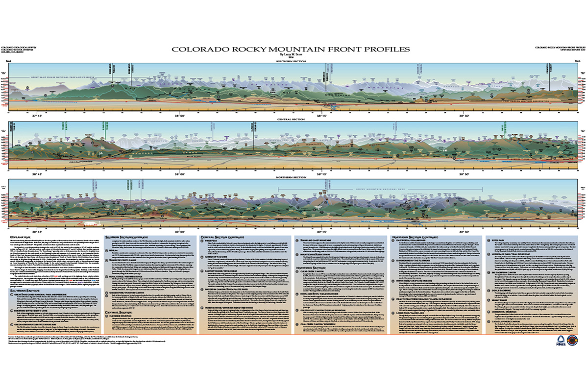
OF-16-03 Colorado Rocky Mountain Front Profiles
2017-05-15 | CGS Admin
(NOTE: We’ are currently rolling over our physical publications sales to Amazon, and we haven’t yet gotten this great poster in stock at the Amazon fulfillment center for shipping as of yet. We hope to issue an updated version at some point in 2023!)
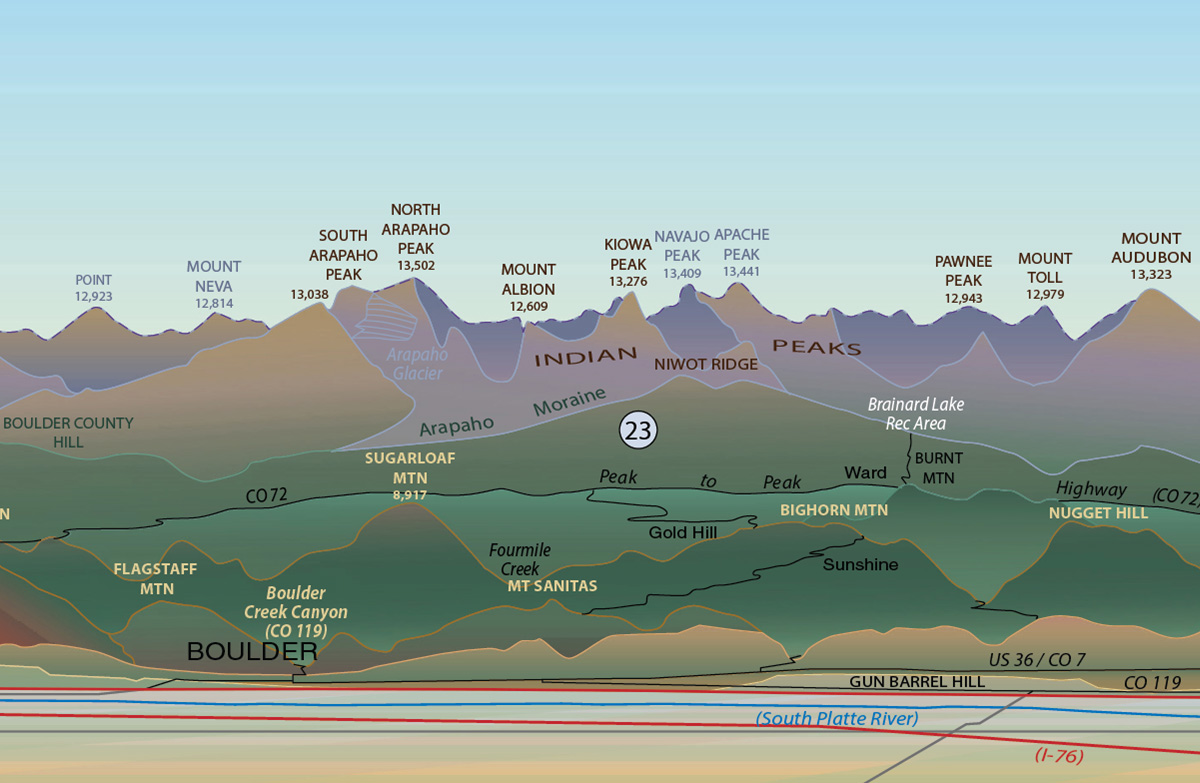
Can you name the features of the endless Rocky Mountain skyline as seen from the Front Range? Where are they actually located? The OF-16-03 Colorado Rocky Mountain Front Profiles poster is the key to finding out. Similar profiles created in the past featured approximate or artistic interpretations of the many summits. This poster accurately locates the elevation points as they exist in geographic space.
The CGS is proud to present this unique perspective of the dramatic Front Range of Colorado as a large 54×28 in (137×71 cm) poster offset-printed on premium glossy stock. The author and designer of this special edition poster, Larry Scott, is a long-time member of the CGS staff. A talented illustrator, he handles the design work on our maps, books, pamphlets, posters, and other print material. This special project is the realization of his long-standing interest in Colorado topography.
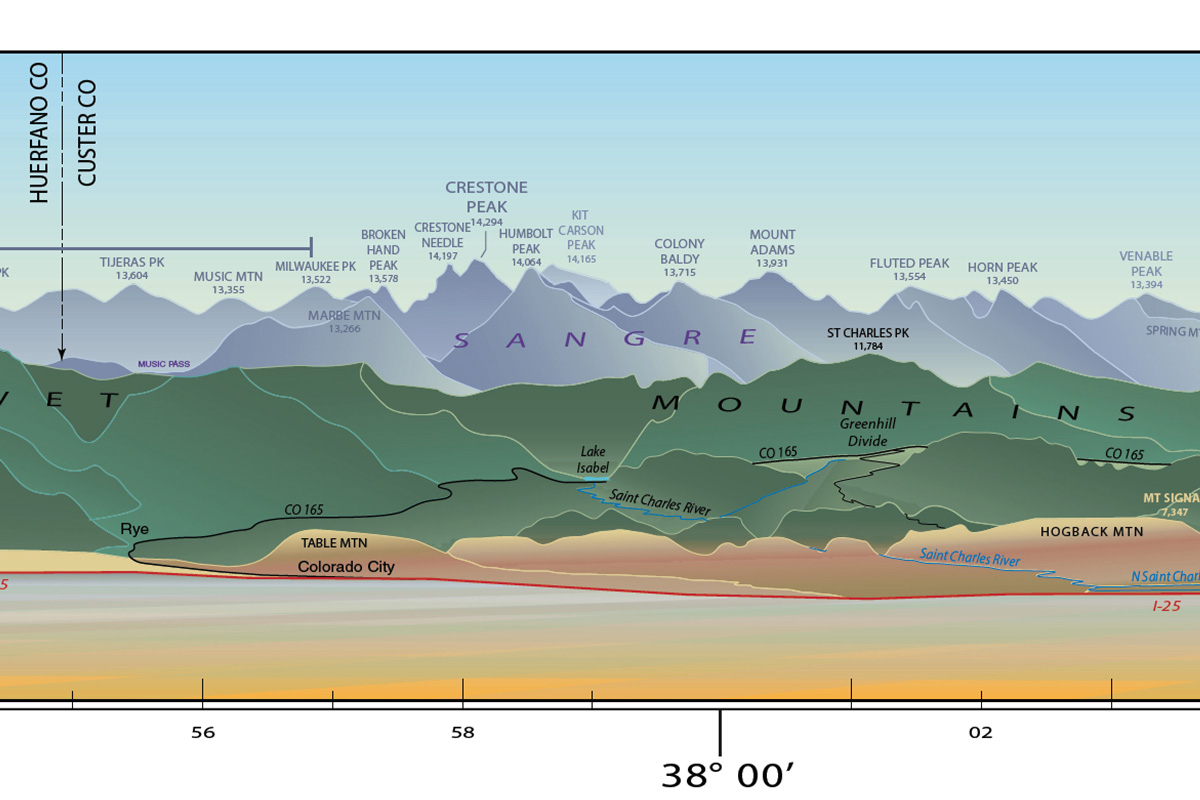
The elevation profiles are drafted horizon lines of the heights of the Continental Divide eastward towards the High Plains. Each mesa, hogback, hill, mountain top, and points in between were plotted by intersecting its specific elevation with its latitude. The relative viewing elevation is about 9,500 ft (2900 m), the halfway point of the vertical scale. This allows one to see what cannot typically be seen from ground-level along the Front Range. If you’ve ever flown into/out of Denver International Airport — altitude 5430 ft (1655 m) — and are sitting on the west side of the plane, this is what you might see a few minutes after taking off or before landing. From this vantage, many of the great mountain ranges of central Colorado to come into view; the Sangre de Cristo, the Sawatch, the Mosquito, and others up to and occasionally beyond the Continental Divide.
Below the three profiles are 32 selected highlights of notable geographic, historic, and geologic locations as indicated via numbered circles. Many of these cite special locations for viewing the various peaks and summits. For example, on a clear day in Denver — something that happens around 300+ days a year — a perfect place to see the mountain horizon is from City Park on the west steps of the Museum of Nature and Science. At an elevation of 5,500 ft (1675 m), this panoramic vista includes much of the Front Range with the downtown Denver skyline in the foreground.
From the Explanation:
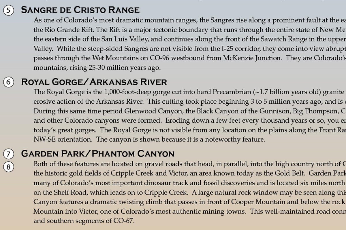
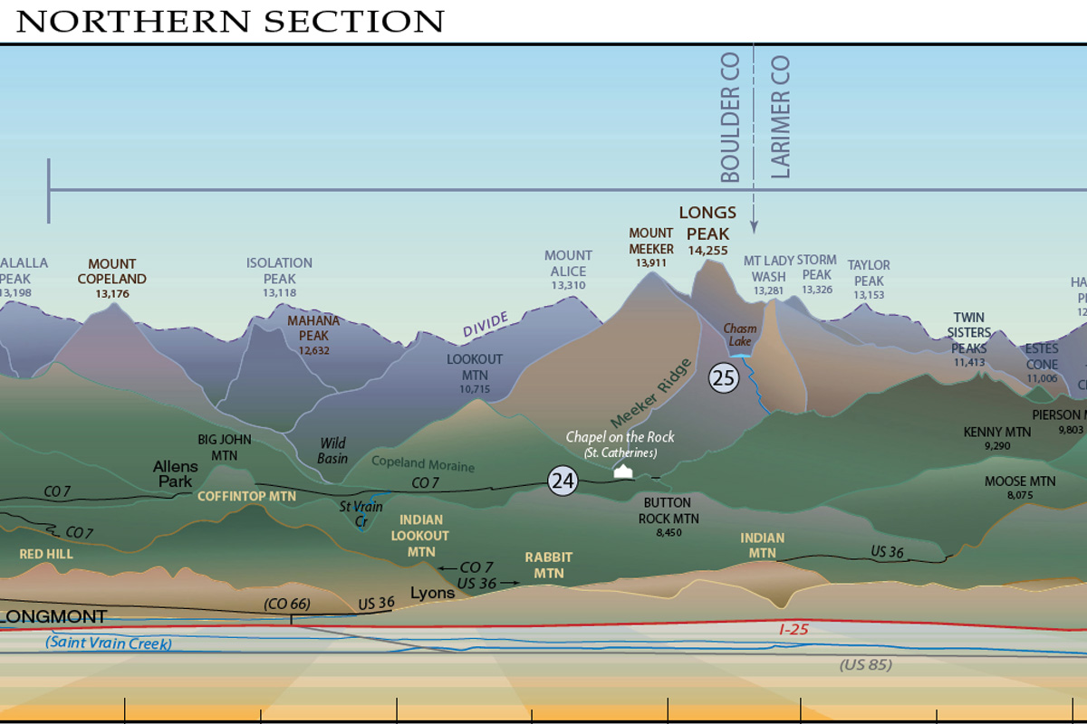
Each profile is a one-degree section beginning in the south at 37° 42′, the central section at 38° 42’, and the northern section at 39° 42’. As the south-north extent of Colorado lies between 37° and 41° latitude, these profiles represent three-quarters of the Colorado Rocky Mountain Front Range. This refers the region of mountains that descend to the plains from the Pikes Peak massif in the south, north to the Wyoming border and inclusive of all summits east to the Continental Divide. South of Pikes Peak, the mountains begin to trend southwesterly all the way to Cañon City where the Arkansas River cuts through the Royal Gorge and flows out onto the piedmont. South of Cañon City, the Wet Mountains form a barrier that drops to the plains along Interstate-25 (I-25). Further south, though not shown, the mountains lay more to the west in a broad stretch, dramatically reappearing in the form of the Spanish Peaks, which extend eastward from the spine of the southernmost Sangre de Cristo Mountains in Colorado, the Culebra Range. To the north, beyond Rocky Mountain National Park, the mountains descend steadily to the Cache la Poudre River, marking the terminus of the Northern Section.
An excerpt:
Clear Creek Canyon — Long before there was an I-70 to access the high country there were only Native American foot trails along Clear Creek. In 1858, after trace amounts of gold were discovered in Cherry Creek south of Denver, gold seekers soon began looking in the mountains. Early in January 1859, George Jackson found gold at “Jacksons Bar”, where Chicago Creek joins Clear Creek in present-day Idaho Springs. The “gold rush” was on and the canyon became the gateway to the mining camps, most notably those in the Central City area via North Clear Creek. The Colorado Central Railroad (1871-1939) occupied the canyon in those days, later becoming the roadbed for US-6. The road was not completed in the canyon until 1952 due to political infighting and the time needed to complete six tunnels in the narrow spots. Rockfall remains a constant threat along the Canyon, with a notably large event closing the road in the summer of 2005 for almost three months—the longest full-road closure in state history.
Citations, Categories & Tags
Citations
Scott, Lawrence. “OF-16-03 Colorado Rocky Mountain Front Profiles.” Profile. Open File Report. Golden, CO: Colorado Geological Survey, May 2017.Categories
General, Geology, Publications
Tags
2010s, CGS, Front Range, gallery, OF-, poster, publication, publications, RockTalk, topography